

Evaluating Nature:
Technical Lands and Ecological Redistribution in Swedish Welfare Planning
On Friday the 19th of April Adrià Carbonell Rabassa will be presenting a chapter from his PhD thesis Evaluating Nature: Technical Lands and Ecological Redistribution in Swedish Welfare Planning. The presentation will include an outline of the overall thesis project, and in-progress drawings and mappings currently being developed. PhD candidate Stavroula Angelaki will be performing as opponent to the work.
Tid: Fr 2024-04-19 kl 13.15 - 16.00
Plats: A608
Videolänk: https://kth-se.zoom.us/j/67185547897
Abstract
Landscapes exist in many different registers. They originate through the interplay of various conceptual and material forms, and are produced through a wide range of means and techniques. They can be vividly painted on a canvas, captured through photographic images, or described in literary narrations. But landscapes can also be shaped by normative frameworks, conveyed through meticulous bureaucratic language and documentation. It is this latter way of writing and mapping landscapes that I want to focus on in this chapter. Here, I examine the use of landscape inventories as a method of landscape evaluation, their use in Swedish welfare planning, and its progressive integration in urban planning and design. By drawing attention to the role that inventories and reports played in the formation of modernist suburban environments, I aim to emphasise how landscape became an essential component of Swedish welfare planning, and how these documents helped shaping what has been termed as ‘welfare landscapes’.
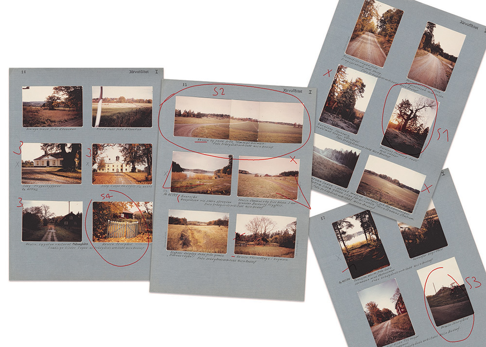
Moreover, the use of evaluation methods entailed the dual task of ‘evalueate’: on one hand to ‘evaluate’, to determine the significance of landscapes by careful study, and on the other to ‘value’, to create or estimate their worth. In fact, evaluating an object inherently involves determining its value. However, landscape inventories transcend mere evaluation; they actively create value through methods of description, classification, and qualification. A primary example to unpack these questions in the context of Swedish welfare planning is the development of the Järva Field area in Stockholm, commonly known as Järvafältet. By studying its long and multifaceted planning process, I analyse the formation of Järvakilen, the longest of the ten green wedges conforming Stockholm’s metropolitan region, and the key role played by the first landscape inventory of the area elaborated by landscape architect Ulla Bodorff between 1966 and 1970.
If you would like to read a draft copy of the work please contact Adrià adriacr@kth.se directly.